If you’ve ever tried to draw a storm drain centerline with side limits, a roadway with curb-and-gutter offsets, or an easement with a buffer band on each side, you already know the moment when AutoCAD’s MLINE command stops being helpful. You either fight with multiline styles, draw three lines manually and offset twice, or build a one-off OFFSET macro that breaks the second the alignment changes.
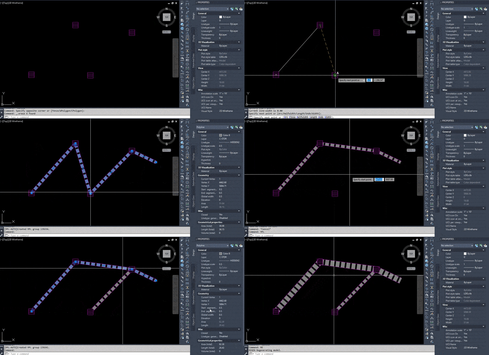
MultiPLine is a small AutoCAD plug-in I built to fix exactly that workflow. Draw one polyline. Get the whole parallel set — every line a real, editable polyline, on the layer you want, with the linetype and lineweight you want.
Why MLINE Falls Short for Civil Drafting
MLINE was added to AutoCAD a long time ago, and it shows. For civil drafting — where you constantly need offset bands around centerlines, easements, and corridors — these limitations come up daily:
- MLINE objects are locked together. You can’t grip-edit, trim, or offset a single component like a normal polyline. You either edit the whole multiline as a unit, or you EXPLODE it and lose the link.
- No per-component lineweight. MLINE components can vary in color and linetype, but polyline width isn’t a concept MLINE supports at all.
- Multiline styles (.mln files) are clunky to share. Each style must be loaded into the current drawing before MLINE will use it. If a teammate opens your drawing without the matching .mln, the style is missing.
- No preset library across drawings. Every drawing essentially starts fresh.
- Editing is painful. Grip-edit a vertex on an MLINE and you’re often better off deleting and redrawing.
For a civil drafter handling dozens of drainage and grading sheets a week, those small frictions add up to real time lost.
What MultiPLine Does
Every satellite carries its own:
- Offset (positive = left of travel, negative = right)
- Layer (Pro edition)
- Color, linetype, lineweight, and linetype scale
Edit the master afterwards — stretch a vertex, move it, change its width in Properties — and the satellites follow automatically in the Pro version, or after a single MPLSYNC call in the free Lite version.
Lite vs Pro — Which One Do You Need?
MultiPLine Lite is free. It includes the full drawing engine, the settings dialog, and MPLSYNC. If you draft for a few hours a day and don’t mind hitting MPLSYNC manually, Lite is genuinely all you need.
MultiPLine Pro adds the things that turn a good drafting tool into a daily-driver:
- Auto-sync. A built-in command reactor watches your master polylines. Grip-edit, stretch, move, rotate — the satellites rebuild themselves. No MPLSYNC calls.
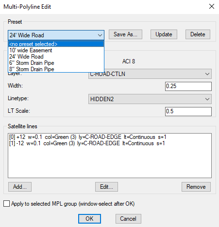
- Named presets. Save your current setup as “Storm Drain 24"", “Roadway”, “30’ Drainage Easement” and pick it from a dropdown in any drawing.
- Per-line layer assignment. Put your centerline on C-STRM-CNTR, edge bands on C-STRM-LIMT — all from one preset.
- MPLADD — promote any existing polylines or lines into MPL groups without redrawing.
| Feature | Lite (Free) | Pro |
| MPL — draw multi-polyline group | ✓ | ✓ |
| Per-line offset, color, linetype, lineweight, LT scale | ✓ | ✓ |
| MPLEDIT settings dialog | ✓ | ✓ |
| MPLSYNC — re-sync after editing the master | ✓ | ✓ |
| Width change auto-scales satellite offsets | ✓ | ✓ |
| Per-satellite layer assignment | — | ✓ |
| Auto-sync on grip-edit / stretch / move / rotate | — | ✓ |
| Named preset library (Save / Update / Delete) | — | ✓ |
| MPLADD — promote existing polylines to MPL | — | ✓ |
| MPLON / MPLOFF — toggle auto-sync at runtime | — | ✓ |
| File format | .fas (AutoLISP) | .fas (AutoLISP) |
Real-World Use Cases
A few configurations I personally save as presets and use almost every week:
Storm Drain Line Style
A centerline (HIDDEN2 linetype, grey, 0.5 width to indicate pipe size) flanked by two thin CONTINUOUS lines for the pipe walls. One preset covers 6”, 8”, 12”, 24” pipes — save four variants and pick by name.
Roadway Cross-Section Indicator
Centerline on the road centerline layer, two parallel lines at half-pavement width on the edge-of-pavement layer, two more outside that on the right-of-way layer. One MPL call gives you the entire roadway band.
Easement and Buffer Bands
Easement centerline on the easement layer, plus a parallel offset on each side at the buffer distance. Edit the centerline once, the buffer follows.
Swale and Drainage Channel
Flowline as the master, top-of-bank lines as satellites. Master on a HIDDEN linetype to flag it as a flow path on plan view.
Installation in Under a Minute
-
Download MultiPLine from the Gumroad. TerraDraft Lite (Free, includes MultiPLine) or MultiPLine Pro
-
Drop the .fas (Lite) or .fas (Pro) file in a stable folder on your machine.
-
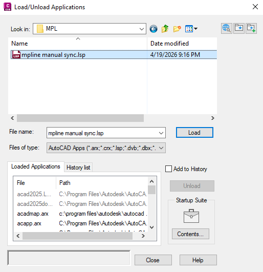
In AutoCAD, run APPLOAD, browse to the file, click Load.
-
Optional but recommended: in the APPLOAD dialog, click Contents… under Startup Suite and add the file so it loads with every new drawing automatically.
You’ll see a confirmation in the command line and can run MPL immediately.
Who This Is For
- Civil drafters who draw stormwater, sanitary, water, roadway, or grading plans every day and are tired of MLINE limitations.
- CAD managers who want to standardize how their team draws cross-sections, easements, and corridors — presets travel between drawings, projects, and machines.
- Land development and surveying teams using offset bands constantly for boundary, easement, and corridor work.
- Anyone on AutoCAD 2025 who wants a cleaner, faster alternative to the built-in multiline workflow.
Get MultiPLine
TerraDraft Lite (Free, includes MultiPLine): [Download from Gumroad]
MultiPLine Pro: [Buy on Gumroad] — one-time purchase, per-user license
If you’ve been wishing AutoCAD’s multiline command worked the way modern civil drafters actually need it to, give MultiPLine a try. The Lite version is free, the Pro upgrade is worth the price for anyone who spends real hours in plan view, and the preset library alone will save you the cost of the tool inside the first week.
Got a use case I haven’t covered? Drop a comment below or reach out — I’m actively expanding the preset library examples and would love to hear how civil teams are using it.
Try it on your own drawing
TerraDraft Lite is free to download.